ALASKA! Finally

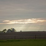
Yesterday, we decided to leave Atlin a day early. The clouds moved in, the temperature dropped and we were worried about hitting rain on the way out.  It was sad leaving this beautiful oasis, but it was time to go. This time I drove the Tracker behind Michael. We had to wait almost 45 minutes at the construction site but made it safely through the worst part of the mud—much to Michael’s relief. We made a quick WAlMart stop in Whitehorse and headed north into the St. Elias mountain range and the Kluane Ice Fields.  Just when you think you’ve already seen the most overwhelming vistas, you come upon another one.

Our campsite in Atlin

Barn Swallow nesting in the eaves of an old building in Atlin

The highway is rough and bumpy with areas of gravel and frost heaves bouncing us all over the place. Poor Lily couldn’t lie down, sit or stand up through most of our ride to Haines Junction, YT where we stayed last night.

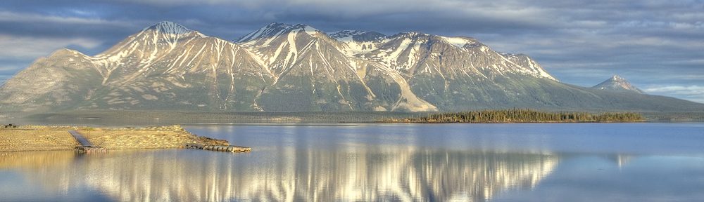
It’s a dreary, rainy day.  As we drove through the Kluane Range, the mountains were ensconced in clouds—as if they did not even exist. At least I got a chance to photograph them  yesterday. Grays blended into deeper grays that blended into clouds as we drove around the lake. No reason to stop (Sorry Danny, we’ll try again on the way back.)

Kluane Ice Fields

After miles of heaving roads, gravel and dirt, flying rocks and dust from 18 wheelers,  we have made it into Alaska. No more meters, liters, kilometers or Celsius.  It’s nice to be back in the US of A. This is probably the longest time we have spent in Canada. I was beginning to speak their language—aye? Really no complaints except for the highway—beautiful country, nice people but very expensive.

We are sitting in a lovely campground in Tok, Alaska about 325 miles from Anchorage. The campground has a Café where we will probably get reindeer chili served in a warm sourdough bread bowl for dinner tonight. They pride themselves on their sourdough pancakes so we may take a shot at those tomorrow morning. Then it’s off to Anchorage and the Kenai  Peninsula.


Atlin, British Columbia

I really don’t quite know where to begin this. I am sitting on Atlin Lake surrounded by snow capped mountains. There is a bald eagle perched on a telephone pole outside my window. Yesterday there were two.  On occasion they are harassed by sea gulls who try to keep them away from their nesting place on a small treed island in the middle of this 60 mile lake.  Just up the road is a small pond with an amazing ecosystem. So far I’ve seen a beaver,  greater  scoup,  red-breasted merganser,  some kind of sandpiper (I think a stilt sandpiper) lots of barn swallows and tree swallows (which graciously eat the voracious mosquitoes) and what I think is either a thrush or warbler of some kind (help me out here Jeff).

Bald Eagle

Greater Scoup-male

Greater Scoup-female

Red-breasted Merganser

Sandpiper

Can anyone identify this bird?

Early yesterday morning we left our campsite outside of Watson Lake and continued north on the highway. Having already completed the most spectacular and mountainous part of the highway the day before,  we easily covered the 210 miles to our turnoff at Jake’s Corner.  Yup, Jake’ s Corner.    This is at the junction of the Alaska Highway and Tagish Road. We gassed up and headed down the 60 miles of road to Atlin. We knew that ¾’s of the road would be dirt and gravel, but we did not anticipate the ongoing construction.  There were a couple of nail-biting moments as Michael maneuvered the motor home with Tracker attached through the mud. At that point I believe my name was mud for insisting that we go to this remote town of 400 people (the most northwesterly  town in British Columbia) in what seemed the end of the world. The trip was worth it!

Directions anyone?

On the road to Atlin

THE road to Atlin

Atlin was founded in 1898 and was one of the richest gold strikes made during the Klondike rush in 1897-98. In fact, the father of the woman who runs the campground, mined gold for years here.  Apparently there are still plenty of streams in the area where people pan for gold but the big rush right now is in Dawson City, YT.  You can walk the town of Atlin in about 20 minutes. Most homes are log and many of the buildings are boarded up.  Fishing and tourism are its mainstay in the summer. Quiet, peaceful and spectacularly beautiful  are the only words I can use to best describe it. Hopefully my images will speak even louder.

Sunrise on Atlin Lake

Sunrise on Atlin Lake #2

A few hours before sunset


Watson Lake, YT

Yesterday, the 290 mile ride from Dawson Creek to FT Nelson was smooth and beautiful.  This initial part of the highway is a relatively  easy drive with snow capped mountains still in the distance.  Though it was  nice  driving on paved road,  and we did not miss the gravel and dirt highway, it didn’t seem like the same adventurous road we had traversed so many years ago. There were still some white-knuckle spots of 9% & 10% grade, curved hills but the ride in general was easy going. We saw 2 dead moose on the highway and 3 live ones(did get a shot of  one), 2 eagles, some deer and 2 sandhill cranes.

The best way to describe Ft. Nelson is benign. There is virtually nothing to this small town to recommend it — one that you would generally pass through without a blink.  Obviously, our experience in 1974 gave it some significance.

After completing 336 miles of incredible wilderness today, we sit in a campground outside of Watson Lake, Yukon Territory. About 20 miles into our drive we entered the Northern Canadian Rockies. These overwhelming  mountains  were covered with morning haze, billowy clouds and snowy peaks.  What a sight as we drove the rugged, bumpy, winding highway. The morning light was perfect.  I kept switching from the 5D with the 24-70mm lens to the 7D with the 100-400mm lens. I couldn’t stop shooting. Every turn in the road brought us another amazing vista. For miles and miles we were virtually alone on the highway.  We rode with the Toad River, the Racing River, the Trout River and the Liard River all the way into Watson Lake, YT. We skirted the beautiful 7 mile Muncho Lake , deep green and blue in color.

Between Ft. Nelson & Watson Lake


Muncho Lake


A stop along the highway

On this ride we saw 3 beautiful black bear and  2 moose, one elk, 3 deer,  lots of bison and 5 stone sheep including a baby. It’s really impossible to photograph  wildlife while we are driving so we just look and enjoy the experience.  However, I was able to get out and photograph the stone sheep that were grazing on the side of the road. They seemed oblivious to our presence.  According to the information in The Mile Post,  stone sheep are indigenous to the mountains of northern BC and southern YT. They are darker and slighter than Big Horn Sheep and are often mistaken for mountain goats.  Dall Sheep are indigenous to the mountains of Yukon, Alaska and Northwest Territories.

Moose running into the woods


Stone sheep & baby

Stone sheep

Tomorrow we plan to take a 3 day side trip to Atlin, BC. 160 miles southeast of Whitehorse.  It is the most northwesterly town in British Columbia and sits on Atlin Lake and boasts  several large glaciers. I have a feeling we may be staying there longer than 3 days. Guess we’ll find out.


June 3-Dawson Creek, BC


June 3, 2011

Woke up this morning to 39° outside, 51° inside.  An abrupt change from yesterday’s  80°. Last night rain clouds gathered around us, the temperatures began to drop, and the combination of  light drizzle along with the setting sun behind us, created a double rainbow on the horizon. At the time we thought of this as a good omen. However, after a night of chilling rain and an even chillier morning with hints of snow, we rethought our optimism.

Rainbow

The hint of snow turned into actuality! They are calling it a “wintry mix” and are expecting just under an inch of the white stuff. We ran out and purchased a portable  space heater to supplement  the propane heating system in the motor home.  Hopefully this will keep the chill off.

Michael in the snow

While I sit out the inclement weather, I figured I’ll  give you a brief history and description of the Alaska Highway. After the bombing of Pearl Harbor on December 7, 1941, the US and Canadian governments felt that we needed a secure land transportation route  to carry military goods, materials and men  from the continental US to Alaska. So in March of 1942, US military engineers and construction workers converged on Dawson Creek, BC exploding the small town’s population from 600 to 10,000. In a little over 8 months the 1,528 mile road was officially completed. It consisted of 133 major bridges, 3000 culverts and cost approximately $140 million US wartime dollars. Since then it has been continuously upgraded, widened and straightened.  Today the official length of the highway, which runs from Dawson Creek, BC to Delta Junction, AK is 1,390 miles.

The highway is 2 lane and winds  through and past incredibly beautiful mountains and lakes. There are steep grades, high summits and unexpected changes in weather. In fact, we experienced a snowstorm in August of 1974 coming over Trutch Mountain.  In 1987, the Trutch Mountain bypass was completed eliminating the trip over the second highest summit on the Alaska Highway.

Despite the weather (it was still snowing and the temperature was around 33°), we decided to go see the Kiskatinaw River Bridge, about 27 miles into the Alaska Highway. The 531 foot long curved bridge is located on the original old Alaska Hwy and is the only original timber bridge built along the highway that is still in use today. It was well worth the trip.

Kiskatinaw River Bridge

Side view of bridge

Freezing my butt off

Michael & Lily under the bridge

We’re supposed to be headed to Ft. Nelson (our nemesis if you read the 70’s blog) tomorrow morning. We’ll see how the weather is.

Backseat driver


Dawson Creek, BC (Mile “0” on the Alaska Highway)

We left Edmonton this morning and along with it we left the flat lands (thank goodness). Highway 43 north took us through rolling hills and lots and lots of trees. Green never looked so good! We drove through logging country, crossed rivers and saw lots of pulp mills. There was virtually no one on the highway.

My favorite road sign so far

Pulp mill on cloud River in Whitecourt, Alberta

Arrived in Dawson Creek, BC and are camping just outside the city. Plan to stay here for 3 days to clean the vehicles, do laundry and see some of the sights. The weather is beautiful with clear skies and billowy clouds. Temperatures hit the low 80’s. It seems the farther north we get the warmer it is. The changes in time zones are really confusing. This part of BC does not switch to daylight savings time. Right now we are 3 hours earlier than the east coast. Also, it is daylight for what it seems forever. I go to bed at 10 pm and it is still light out.  This too takes some getting used to. However, it’s just nice knowing that we have arrived at the beginning of the Alaska Highway after driving 3131 miles.

Welcome to the Alaska Highway

Mile "0" on the Alaska Highway

Am tired and  hot and will stop for now.


Edmonton, Alberta

Flat, flat, flat. That’s all I can say about Saskatchewon. At least the rain stopped by morning. Our campsite was flooded but we had no trouble getting back on the road. The sun came out,  the wind abated and the drive was relatively smooth.

Flooded campground Regina, SK

Michael decided that he wanted to make this a long drive day of about 500 miles and make it to Edmonton.  We stopped briefly to make some lunch and  ate along the way.

Got our first sticker shock re gas prices in Canada: $4.77 a gallon (we did the conversion from liters). The lowest we saw was $4.47. Have no idea what the prices will be like on the Alaska Highway.

We plan to stop at Dawson Creek tomorrow and spend 2-3 nights. We need to do some laundry and clean off all the mud. It is so nice to be out of the rain.

Because of the per minute costs in Canada,  we are only using our Droids to contact campgrounds. Otherwise, we have them turned off.  Consequently we no longer have access to a GPS or an internet connection. That’s why we are looking specifically for campgrounds that have WiFi. Our main resources are a Rand McNally road atlas, an RV Parks and Campgrounds Directory and now, the Milepost which consists of 782 pages of highways and cities along the Alaska Highway and throughout all of Alaska—mile by mile. It’s a lot easier to just go online to figure our routes  and select campgrounds. At times I’m juggling all 3 books checking maps, looking for routes  and trying to locate campgrounds in the middle of nowhere. I do have use of a laptop so I can do some writing while we are driving.  And ,of course, I can work on my photography on our desktop in the bedroom.

So we are not exactly electronically deprived. We’ve had no TV since WV. However, XM Radio has been working just fine even in Canada so we do keep up using the news.

For entertainment (ha, ha) we either watch a DVD or read. Our expenses, other than gas, have been relatively low. Campgrounds run us on average $30 a night and food, which we have been buying at local Wal Mart’s, is about the same as at home.  We don’t eat out at all so that saves us some money.  Camped in a huge campground outside of Edmonton for the night. The weather is clear and pleasant. A welcome change.


Regina, SK, Canada

May 30, 2011

After a night of torrential rains and wind we decamped and drove the 3 miles of dirt road to the paved highway. It was touch and go for a while as we zigzagged over muddy ruts with the motor home spinning out several times. But we made it safely (thank you Michael) and headed north to the Canadian border. It took us an hour to go through immigration (thanks to 9/11). Besides being questioned by at least 3 “officials”,

This is not a lake in front of this house!

our motor home was searched. Desperadoes that we are, they found nothing unsavory and sent us on our way. Actually everyone was pretty nice.

The ride through the rest of North Dakota and into Canada was windy (20-40mph winds) and rainy. Lakes covered unplowed fields everywhere we looked. It was so windy that some of the windmills were not in operation. We even saw an occasional oil rig pumping away in the middle of a waterlogged field. We are so tired of the rain and wind. But it looks like we will have at least another 2 days of this mess.

Flooded field in ND

Oil Rig

We are camped at a very nice campground outside of Regina, Saskatchewan, Canada. Tomorrow we will head to Edmonton.

Three of the 5 images were taken through the window of the motor home. Note the roll of wheat in the field (yes that’s a field) and the oil rig. By the way, that is not a lake in front of that house. I’ve included 2 birds. Unfortunately the rufous-sided towhee is not up to my usual quality. I had no choice but  to shoot it back lighted and had to contend with chromatic aberration and noise. However, it is such a pretty bird and one that I had never seen before that I included it.

Gray Catbird

We are cell phoneless for now. Are trying to find campgrounds that have wifi such as this one. You can communicate with us through email or on the blog.

Michael’s 63rd Birthday

Just a brief post on this very relaxing Sunday before we take off for Canada.

Michael relaxing on his birthday

Finally caught a sunrise this morning. Unfortunately those magnificent clouds were gone. Guess you can’t have everything. Spent a lazy day walking, reading and cleaning up the motor home.

The sun coming over the hill

A fisherman on the lake

(Click on images to enlarge)